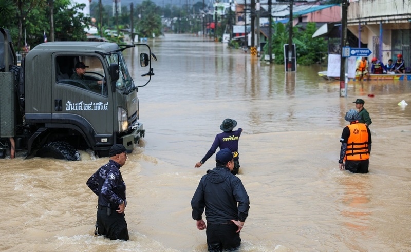
Flooding of Hat Yai, one of the most significant commercial centers in southern Thailand, is becoming more serious and frequent in 2025, and the issue of long-term resilience is rather urgent. According to the recent changes in satellite observations, drastic changes in land patterns, water flow behavior, and changes in climate-related rainfall intensity have been observed, which impact the vulnerability of the city. Hat Yai has been experiencing seasonal effects of monsoons all along, but the new information reveals a structural gravitas of a more serious change due to the high rate of urbanization, lack of green buffer, and damaged drainage networks. Since the climate is becoming more volatile than ever, it is important to find out why Hat Yai has become more prone to floods to help policymakers, residents, and urban planners to be prepared in the coming ten years.
Satellite Data Indicates the Natural Buffers are Shrinking around Hat Yai
According to new satellite images of 2025, the natural floodplains and wetlands around Hat Yai have diminished tremendously within the last five years. Spaces that used to absorb and slow down the runoff water have been taken over by growing commercial premises, roads, and housing complexes. The changes have augmented the surface heat absorption of the city and water retention capacity when there is heavy rainfall.
Besides, deforestation in the outer districts is changing waterflow channels. Moisture accumulation that is tracked by satellites indicates that the Khlong U-Tapao Basin discharges water towards Hat Yai at more rapid and unpredictable rates. Monsoon bursts result in the city having a fast-flood effect, where the water starts accumulating in hours rather than days.
These facts bear out what local environmentalists have been squealing about all along: the development in Hat Yai is proceeding at a rate much higher than the infrastructure necessary to safeguard it.
Increasing Rainfall and Overloaded Drainage Systems in 2025
One more significant reason why Hat Yai is at risk of floods is that the number of extreme rain events has increased considerably. Temperature variations in the Andaman Sea due to climate are causing more intense and shorter rainfalls, which surpass the drainage system.
Analysis of satellite rainfall at the beginning of 2025 underlines an increase to a maximum of 18% in precipitation during rush hours over Hat Yai, which causes more frequent stormwater flooding of the streets, houses, and business premises. The drainage canals that were built in the past decades are either too narrow, too shallow, or are overwhelmed by the construction debris in the urban centers.
To make matters worse, the city is being developed at a high rate, thus augmenting the amount of runoff. There is no room to retain the percolation, so the rainwater finds its way into the canals rather than dripping into the ground. This overwhelms the system and creates flash flooding even in the neighbourhoods that used to be historically less affected.
Urban planners reiterate that, in the absence of upgrades, Hat Yai might experience massive floods several times annually, rather than the infrequent floods that used to happen in the past.
Disclaimer: Stay updated with the lastest news, from politics to business trends, while also catching up on the lastest news in sports covering matches, scores, and tournaments. Explore the latest news in entertainment with celebrity updates, movies, and shows, and don’t miss the latest news in games, featuring trending releases and esports highlights.