As the Philippines monitors the approach of Typhoon Bavi, which is expected to be named Bagyong Inday once it enters the Philippine Area of Responsibility (PAR), many Filipinos are preparing for days of heavy rain and possible flooding. While additional weather forecasts have suggested that the cyclone may not reach land, the weather department has said that its vast circulation might make a significant influence on the southwest monsoon also called “Habagat” resulting in widespread rains to occur in several parts of the country.
Given that flooding is one of the most significant threats during the enhanced monsoon period, the public is advised to determine the flood hazard of any home, workplace or travel route. A great resource to do this is Project NOAH, an online platform for hazard mapping that can assist users with their flood risk until before a severe weather event.
Why Is Flooding Still Possible Even Without Landfall?
Many people think that a typhoon which passes over its own lands poses danger only when its eye comes on land. However, this is not always the case. When the large tropical cyclones draw in large quantities of moisture, the monsoon rainfall can be persistent and heavy very far from the center of the cyclone.
As is forecast, Super Typhoon Inday is likely to bring more rains from the Habagat as opposed to devastating eyewall wind. This would lead to flashflooding and river bank erosion being the major risks, particularly in low landscape level communities and rugged terrain.
What Is Project NOAH?
Project NOAH (Nationwide Operational Assessment of Hazards) is an initiative that moves disaster information that could help Filipinos understand the hazards in the natural environment. It describes in detail the locations of flood & landslide prone zones and areas at risk from such weather hazards.
It integrates geographic information, rainfall data and hazard analysis in an intelligent manner to assist citizens in preparing for disasters. It is extensively adopted by the local government units, local planners, disaster researchers, and local communities for disaster preparedness.
How to Check If Your Area Is Flood-Prone?
For beginners as well as those who have used Project NOAH before, it’s fairly easy. Go to the official Project NOAH website and enter your province, city, municipality or barangay in the search box.
When you come up on your location, turn on the flood hazard overlay. The map will be displayed with different flood susceptibility levels, as indicated by color coded overlay. Zoom in to see if your neighbourhood or nearby roads, schools or workplaces are located in areas where the risk of flooding is low, moderate or high.
Locate your rivers, waterways and drainage systems to see how they compare with each other, and to get a better idea of what could happen around you if there is heavy rainfall. Before a disaster, a family has time to plan what they will do if they need to evacuate by referring to these maps.
Areas That Should Pay Close Attention
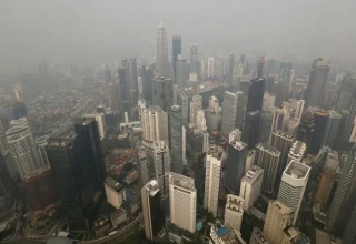
If the Super Typhoon Inday’s track keeps unchanged, western Luzon is just the area which will be hit by the most monsoon rains as PAGASA continues to refine its forecast track of the typhoon. Residents should continue to closely follow official wind and weather updates in Metro Manila, Central Luzon, Calabarzon, Mimaropa and Western Visayas, which are battered by the southwest monsoon.
Everyone who resides near rivers, creeks, coastal areas and landslide prone mountain slopes must be particularly cautious as continuous rain can easily alter the local conditions.
How to Prepare Before Heavy Rain Arrives?
With relatively quiet weather kicking in this year, it is a great time to get ready. Ensure adequate drainage around homes, check for loose materials on roofs, and cut tree branches that may fall down during a storm.
Make an emergency kit of water, food, flashlights, power banks, medications and important paperwork in watertight bags. You can also stay in touch with your mobile phone and regularly check official advisories in order to react quickly to deterioration in weather conditions.
Traffic is not to be used to cross flooded streets and commuters are reminded to check transport warnings as very heavy rain may cause traffic disruptions and classes may be suspended.
Stay updated with Malaysia’s latest changes.
Which Apps Keep Kids Connected?
Check out safe communication apps after Malaysia’s social media ban.
How Can You Cross Borders?
Find the legal way to take a taxi from Malaysia to Singapore.
Know Malaysia’s Betting Rules?
Uncover the legal risks and penalties for online sports betting.
Will Haze Return This Year?
See when severe haze could affect Singapore and Malaysia again.
Need Free Medicine Delivery?
Get to know how to register for Malaysia’s home medicine service.
Continue Following Official Weather Advisories
As tropical cyclones develop they can change their forecast track and intensity. But apart from social media posts, always check what PAGASA, the local government agencies and the National Disaster Risk Reduction and Management Council (NDRRMC), and other official agencies have to say about the situation.
Stay alert for news bulletins of rainfall warnings and flood advisories, or Tropical Cyclone Wind Signals, which could be issued when this system moves towards the Philippines Area of Responsibility.
FAQs
Will Inday super typhoon hit the Philippines?
As per the latest forecast models the cyclone will take no landfall path. But the predictions could change and the storm could significantly intensify the Southwest monsoon and cause heavy rains in many parts of the country.
What is Project NOAH?
Project NOAH is a web-based hazard mapping system that offers hazard information such as flood, landslide and other hazard data to communities across the Philippines. It assists residents to become aware of hazardous areas prior to bad weather.
In which areas of the country would you anticipate heavy rainfall from the landfall of Super Typhoon Inday?
Some parts of Luzon, notably Metro Manila for now, and several parts of the Visayas as well as other areas under southwest monsoon influence could see a break in their light rainfall.